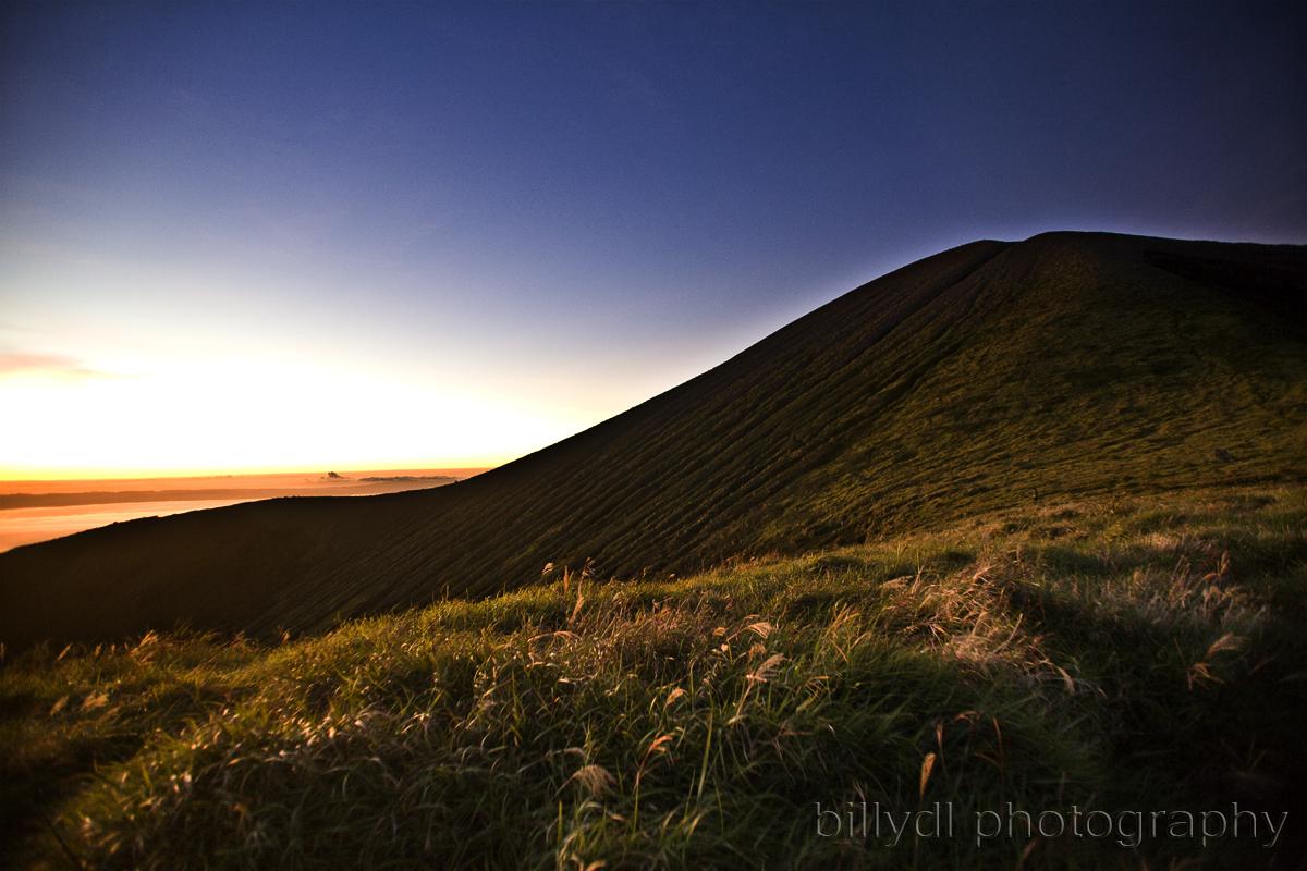
Monday, 15 February 2016

Mt. Kanlaon

Kanlaon Volcano, also spelled as Kanla-on or Canlaon, is an active volcano on Negros Island in central Philippines. The stratovolcano straddles the provinces of Negros Occidental and Negros Oriental, approximately 30 km (19 mi) southeast of Bacolod City, the capital and most populous city of Negros Occidental.
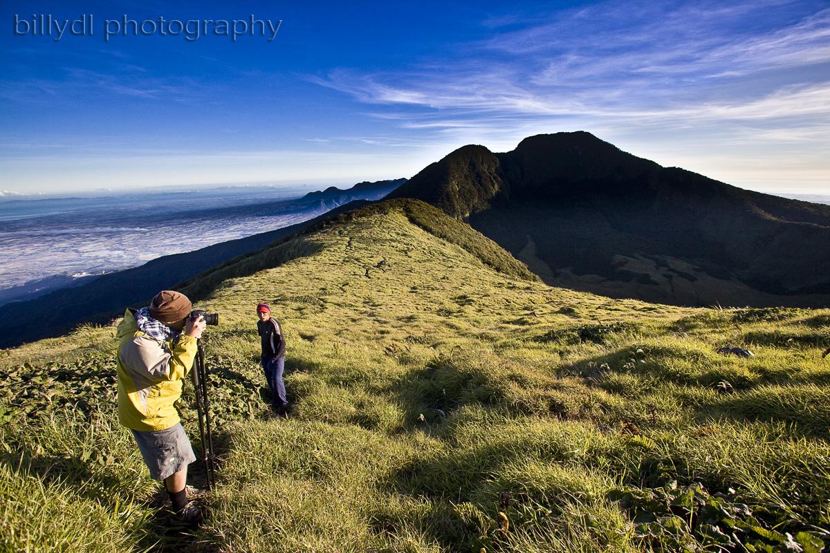
The volcano is a favorite spot for mountain climbers and is the centerpiece of Mt. Kanlaon Natural Park, a national park originally established on August 8, 1934. It is one of the active volcanoes in the Philippines and part of the Pacific ring of fire.

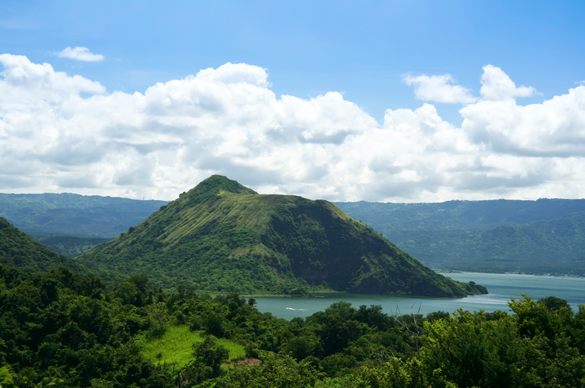
Kanlaon has a peak elevation of 2,435 m (7,989 ft) with a base diameter of 30 km (19 mi) and is dotted with pyroclastic cones and craters. Just below and north of the summit is the active Lugud crater. North of Lugud is a 2 by 0.8 km (1.2 by 0.50 mi) caldera, known as Margaja Valley, with a crater lake.
The volcano has three hot springs on its slopes: Mambucal Hot Springs on the northwest, Bucalan Hot Spring, Bungol Hot Spring. Its adjacent volcanic edifices are Mt. Silay and Mt. Mandalagan, north of Kanlaon.

The city center of Canlaon City, the city that has jurisdiction on the Negros Oriental side of the mountain, lies on its lower slope about 8.5 km (5.3 mi) ESE of the summit.
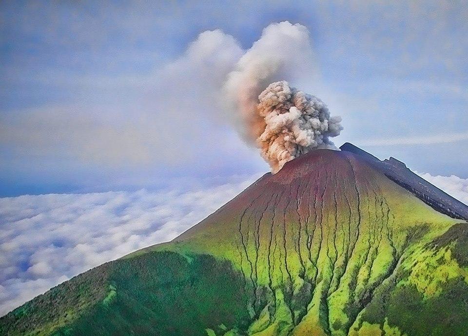
The most active volcano in central Philippines, Kanlaon has erupted 26 times since 1919. Eruptions are typically phreatic explosions of small-to-moderate size that produce minor ash falls near the volcano. In 1902, the eruption was classified as strombolian, typified by the ejection of incandescent cinder, lapilli and lava bombs.

Volcanic activity at Kanlaon is continuously monitored by the Philippine Institute of Volcanology and Seismology (PHIVOLCS), the government's bureau that monitors the volcano and earthquakes in the country. Kanlaon Volcano Observatory is located at the campus of La Carlota City College in Bgy. Cubay, La Carlota City in Negros Occidental province.
On August 10, 1996, a group of 24 mountain climbers were on the summit of the volcano when Kanlaon suddenly erupted without any warning killing British student Julian Green and Filipinos Noel Tragico and Neil Perez, who were trapped near the summit. The authorities rescued the 17 others, including 10 Belgians, another Briton and six Filipinos.

One of the Belgians, Caroline Verlinde, said she and her group were about to leave a site near the crater rim when suddenly the volcano ejected ash and stones. She ran to a tree for cover and saw her friends being hit by falling stones. She said their Filipino guide told them the smoke billowing out from the crater "was just hard."
On June 3, 2006, Kanlaon again exhibited restiveness and spewed steam and ash., issued Alert Level 1 (mild restiveness) on June 12, 2006.
On February 10, 2008 PHIVOLCS issued an alert stating that the seismic network at Kanlaon Volcano recorded a total of 21 low frequency volcanic earthquakes (LFVQ) during the past 24 hours. Due to the increasing number of recorded volcanic earthquakes, PHIVOLCS raised Kanlaon Volcano’s alert status from Alert Level 0 to Alert Level 1, which means the volcano is at slightly elevated unrest and volcanic activity could lead to steam and ash ejections. A 4-kilometer (2.5 mi) Permanent Danger Zone (PDZ) was maintained around the volcano, as sudden explosions may occur without warning, but no eruptions occurred.

In the 8 days from 23 August to 1 September, 257 volcanic earthquakes were recorded. Usual seismic activity during quiet periods is 0 to 4 quakes in any 24 hour period. Epicenters of the recorded quakes were clustered at the north-west slope which may indicate movement of an active local fault at the slope induced by pressure beneath the volcano. Surface observations did not show any significant change in the steam emission from the crater. PHIVOLCS maintained the alert status at Level 0.

The Prosperous Land of South Cotabato

Overview
South Cotabato is a province of the Philippines located in the SOCCSKSARGEN region in Mindanao. Its capital is Koronadal City, and it borders Sultan Kudarat to the north and west, Sarangani to the south and east, and Davao del Sur to the east. To the southeast lies Sarangani Bay.
General Santos City, on the shores of Sarangani Bay, is the largest and most important city in the region, and is a major seaport. The province of Sarangani used to be part of South Cotabato until it was made an independent province in 1992.
South Cotabato is a natural haven for both tranquil and intrepid endeavors. It has all the cityscape extras one may want for a comfortable stay without the big city worries. Everything here is charmingly unassuming and laced with rustic appeal. This laid back way of the sets the province’s tempo of many striking contrasts that blend the east with the west, the old- world with contemporary and everyday to the exotic.
Discover our distinct culture renowned for its T’nalak weaving and set out on a cultural Odyssey. South Cotabato is a showcase of diverse cultures with interesting mutual ties, all resonant, vibrant and mysterious. Embrace the outdoors and set adrift on a boat and be introduced to our majestic Lakes or trek up to the scenic mountain terrain to come across a hidden treasure trive of stunning sights coupled with unsurpassed flora and fauna. Like the cascading waterfalls of Lake Sebu set amidst a verdant panorama or take a different path and traverse up Mt. Melibengoy to behold the wonders of Lake Holon.

The Hundred Islands National Park is composed of mainly of 124 islands which features white-sand beaches and forested inland. The islands are popularly known for its magnificent natural geological formations. This protected area is situated in Alaminos City, Pangasinan.

The islands are scattered in Lingayen Gulf covering an area of 16.76 square kilometers. It is believed that the ‘hundred islands’ are about two million years old and actually ancient corals that extend well inland, in an area previously comprising the seabed of an ancient sea. The lowering of the sea level has exposed them to the surface.
As a tourist destination, the Hundred Islands National Park is ideal for swimming, diving and snorkeling. There are only three among the hundred islands that are developed for tourism. Majority of the islands are not commercialized and are still unspoiled. The islands are truly a natural wonder because of the unique karst formations and forest.

Puerto-Princesa Subterranean River National Park (also called Puerto Princesa Underground River) is a protected area in the country which features a spectacular limestone karst landscape and an underground river. The site represents a significant habitat for biodiversity conservation and boasts a full ‘mountain-to-sea’ ecosystem.

Because it represents a unique ecosystem and features the most important forests in Asia, it was declared by UNESCO as a World Heritage Site on December 4, 1999. On November 11, 2011, Puerto Princesa Underground River was provisionally chosen as one of the New7Wonders of Nature and was officially confirmed on January 28, 2012.
The cave inside the national park is one of the largest cave rooms in the world while the river winds through it before flowing directly into the West Philippine Sea. The forest formations represent eight of the thirteen forest types found in Asia such as mountain forest, beach forest, and mangrove forest.
Asik-asik Falls, North Cotabato

- A newly discovered water fall, Asik-asik falls is becoming a new tourist destination in the Philippines. Located in the remote sub-village of Dulao, Barangay Upper Dado, Alamada, North Cotabato, Asik-asik falls is the Only Waterfall Spring in the Philippines. 

What’s unique and best of this spot is that the water sprouts from the rock on a cliff at the edge of a hill. Thus, the water flows from the wall of the rocks. It has even being tagged by the National Geographic Channel as the "No-River-On-Top Falls" because of this unique formation of the water-spring falls.

Photo courtesy by: Ferdinand Cabrera
Indeed, this newly discovered attraction is one of the natural wonders of Mother Nature and one of the best nature spots in the country which possesses pristine and a quaint sight of natural world.

There are more nature spots that can be seen and found in the Philippines aside of the above-mentioned destinations. The Top 10 results are based on the author’s point of view of the article’s topic. Hence, it will not reflect directly to other’s perception of the best nature spots in the Philippines. Moreover, the selected natural wonders are being carefully examined, researched, and chosen by the author on his journey on traveling and exploring the best spots in the Philippines.

Chocolate Hills, Bohol

- Bohol’s signature-attraction, the Chocolate Hills is the jewel of Bohol Tourism and is considered as one of the World’s Famous Natural Wonders.

It is called the Chocolate Hills because during the summer, the cone-shaped hills covered with green grass dries up and turns into chocolate-colored hills which is naturally beautiful.

According to the Seven Natural Wonders, there are at least 1,260 hills but there may be as many as 1,776 hills spread over an area of more than 50 square kilometers (20 sq. miles).

Fast Facts:
The Chocolate Hills form a rolling terrain of haycock hills-mounds of a generally conical and almost symmetrical shape. Estimated to e from 1,268 to 1,776 individual mounds, these coned-shaped or dome-shaped hills are actually made of grass-covered limestone. (wikipedia.com)


Also known as the “Chocolate Kisses”.

Photo source:  http://akoyatangpinoy.blogspot.com/
Mt. Apo, Davao

- Mount Apo is best known as the country’s highest peak towering at 2,954 meters (9,672 ft) above sea level located between Davao City, Davao del Sur, and Cotabato Province. Being the highest mountain and volcano in the country, Mount Apo is also known as the Grandfather of Philippine Mountains.

It is also one of the best nature spots because aside of being the most popular climbing destinations in the country and a climber’s dream destination, it also houses the Second World’s Largest Bird and Country’s National Bird called the Philippine Eagle (Pithecophaga Jeffreyi). Not only that, the mountain is also an home to over 272 bird species, 111 of which are endemic to the area, 69 families of amphibians, reptiles and mammals and 118 species of butterflies. Plus the fact that the King of Fruits called the Durian grows abundantly to this area.

A true grandeur!

Mt. Apo possesses a formidable array of landscapes, from craggy rockscapes to virgin forest; from mossy swamps to volcanic structures. The mountain possesses the widest spectrum of environments, and provides an experience for mountaineers that lives up to their expectations from the country’s highest.

Maria Cristina Falls, Iligan City

Photo source:  http://www.luzpalma.com/
- The Maria Cristina Falls is the Second Highest Falls in the Philippines with a 320 feet high waterfall which is located in the boundaries of Barangay Maria Cristina, Ditucalan, and Buru-un, Iligan City, 9.3 kilometers away southwest of the city proper.

Maria Cristina Falls is sometimes called the “twin falls” as the flow is separated by a rock at the center of the waterfall. Maria Cristina Falls considered as the most splendid falls among the 23 waterfalls found in Iligan City mainly because it offers an alluring natural beauty and grandeur of Mother Nature. As a matter of fat, is it called as the Mother of Industry and Fountainhead of Progress because it generates 70% of Mindanao’s electricity system.
Taal Volcano, Batangas

- Where can you find a volcano within a lake within a volcano within a lake within an Island within a sea? The answer is located between the towns of Talisay and San Nicolas in Batangas well known as the Taal Volcano.

Taal Volcano is a complex volcano, the Smallest Active Volcano in the World, and part of a chain of volcanoes along the western side of the edge of the island of Luzon, which were formed by the subduction of the Eurasion Plate underneath the Philippine Mobile Belt.

It is one of the best nature spots because it offers and provides a picturesque and panoramic view to its tourists. And what’s unique about this nature wonder is that it is a volcano within a lake called the Crater Lake within Volcanoes called Volcano Island and Mt. Macolod surrounded by another lake called the Taal Lake within an Island of Luzon surrounded by the West Philippine Sea.

Fast Facts:
Permanent Settlement in the island is prohibited by the Philippine Institute of Volcanology and Seismology or PHIVOLCS, declaring the whole Volcano Island as a high-risk area and Permanent Danger Zone (PDZ).

Hundred Islands, Pangasinan

- Hundred Islands National Park is a group of Islands with 124 islands at low tide and 123 at high tide scattered along the Lingayen Gulf located in the Alaminos City, Pangasinan.

It covers an area of 18.44 square km (4,557 acres) and believed to be about 20 million years old. Some of the islands are actually have the peculiar “mushroom”-like shapes.

What made it on the list of the best nature spots in the Philippines is that it is wildlife and a home of the following animals. These are monitor lizards, crab-eating macaque, dugong, fraser’s dolphin, common palm civet, laticauda colubrina, olive ridley, green sea turtle, species of red turtle, gecko, various bat species and rodent species.

Tubbataha Reefs Natural Park

- Nominee for the New 7 Wonders of Nature, Tubbataha Reef is a marine sanctuary, an atoll coral reef located in the Sulu Sea which is protected by UNESCO World Heritage Site as Tubbataha Reef Natural Park.
Photo source:
http://www.tourism.gov.ph/

Tubbataha Reef is one of the best nature spots in the Philippines because it houses two atoll coral reef systems. Small coral island is about 3 miles (5 km long) and 3 km wide while the larger coral reef island is approximately 10 miles (16 km) long and 3 miles (5 km) wide. The atolls are actually the sanctuary for more than 1,000 species of coral, fish, and even numerous bird lives. Sadly many are considered as endangered.


Fast Facts:
Aside from being a marine sanctuary, Tubbataha is also renowned for being a bird sanctuary. Around the Tubbataha, there are tens of thousands of masked red-foot bobbles, terns, and frigate birds resting during their annual migration.
Chocolate Hills, Bohol
- Bohol’s signature-attraction, the Chocolate Hills is the jewel of Bohol Tourism and is considered as one of the World’s Famous Natural Wonders.

It is called the Chocolate Hills because during the summer, the cone-shaped hills covered with green grass dries up and turns into chocolate-colored hills which is naturally beautiful.

According to the Seven Natural Wonders, there are at least 1,260 hills but there may be as many as 1,776 hills spread over an area of more than 50 square kilometers (20 sq. miles).

Fast Facts:
The Chocolate Hills form a rolling terrain of haycock hills-mounds of a generally conical and almost symmetrical shape. Estimated to e from 1,268 to 1,776 individual mounds, these coned-shaped or dome-shaped hills are actually made of grass-covered limestone. (wikipedia.com)

Also known as the “Chocolate Kisses”.

Mount Mayon, Albay
- Best known as the Mayon Volcano, Mount Mayon is an active volcano        located in Legaspi City, Albay. It is one of the best nature spot in the       Philippines mainly because of its “perfect cone” formation which is almost in symmetric conical shape.

Bulkang Mayon (locally coined term) is actually the most active volcano in the Philippines with over 48 times recorded eruptions in the past 400 years.

Fast Facts:
The most destructive eruption of Mayon occurred on February 1, 1814. The Volcano was belching dark ash and eventually bombarding the town with tephra that buried the town of Cagsawa.

Today, only the bell tower of the Church of the Cagsawa which was largely destroyed during the 1814 eruption of the said volcano.


Boracay Island
  - Formed like a dumb-bell and best known as a vacationer’s paradise, Boracay Island is one of the best beaches in the world and always on the list of the best beach destinations in Asia because of its 4 km long powdered-like white sand beach and the crystal clear turquoise water.

Boracay Island has 12 beaches to count. The most famous is the White Beach which most of the Night Life, establishments such as hotels, restaurants, shopping malls, and bars are situated. Bulabog Beach on the other hand is directly opposite and is the secondary water sports beach which mainly protected by a great reef.

Aside of its famous white sand, Boracay Island also have one of the best sunsets in the world that will surely inspires you to enjoy life and live to the fullest. That is why it is being tagged as a vacationer’s paradise.

Fast Facts:
By the 1990’s, Boracay’s beaches were being acclaimed as the best in the world. In 2012, the Philippine Department of Tourism reported that Boracay had been named the World’s Second Beach Beach after Providenciales in the Turks and Caicos Islands.

Boracay was awarded in the “Travelers’ Choice 2011” by Trip Advisor as the Second Best Beach (out of 25) in the World”.

Boracay made a debut appearance in the Top 10 Islands list in the Travel+Leisure travel magazine World’s Best Beach Award 2011, ranking fourth.

“It’s Boracay, not Bora!”- The newest campaign of Boracay Island stating that Boracay is different from that of the Bora-bora which is also a white beach on other country.

Puerto Princesa Underground River, Puerto Princesa, Palawan
-      One of the New Seven Wonders of Nature, The Puerto Princesa Underground River (PPUR) is indeed one of the most astonishing and amazing cave systems in the world. Located in the Saint Paul Mountain Range about 76 km north of the Puerto Princesa City, Palawan, the PPUR is the Longest Underground River in Asia and the Second Longest Underground River in the World with an 8.2 km long traversable underground river that directly flows to the sea.

Also known as St. Paul’s Subterranean River and Puerto Princesa Subterranean River National Park, the PPUR is actually one of the most protected areas of the Philippines.

What’s the wonder of this underground river is that it is naturally-inspired by Mother Nature. As the New 7 Wonders of Nature stated, “At the mouth of the cave, a clear lagoon is framed by ancient trees growing right to the water’s edge. Monkeys large monitor lizards, and squirrels find their niche on the beach near the cave.”

Meanwhile, it features a limestone karst mountain landscape with a full mountain landscape with a full mountain to sea ecosystems and protects a forest which includes major formations of stalactites and stalagmites, and even several large chambers inside the underground river.

Just don’t be surprised to see naturally sculpted arrays of stalagmites and stalactites that forms like Pegasus-the winged horse of Hercules, or the Last Supper of Jesus Christ. Not only that, expect to witness the formation of fruits and vegetables inside the cave, religious figures or even the extinct formation of a T-rex.

Fast Facts:
The discovery of 11 minerals, scientifically and aesthetically unique speleothems, and a 20-million year old Serenia fossil permanently embedded in the walls of the cave justifies the declaration of the PPUR as one of the 7 Wonders of Nature.